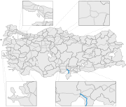
Yeşilköy, Hatay
Neighbourhood in Dörtyol, Hatay, TurkeyYeşilköy is a neighbourhood of the municipality and district of Dörtyol, Hatay Province, Turkey. Its population is 10,436 (2022). Before the 2013 reorganisation, it was a town (belde). It is situated between Nur Mountains and the Mediterranean Sea coast. Turkish state highway D.817 is to the west, Çukurova Motorway is to the east and Dörtyol is to the south of the town. Yeşilköy is almost merged to Dörtyol. The distance to Antakya is 90 kilometres (56 mi). Yeşilköy was declared a seat of township in 1968. The main agricultural crops are citrus and vegetables. The town is in a flourishing industrial area. Services to summer houses around the town also constitute a part of town revenue.
Read article
Top Questions
AI generatedMore questions
Nearby Places

Issus (Cilicia)
Ancient Greek archaeological site in Turkey
Battle of Issus (194)
Battle between Septimius Severus and Pescennius Niger (194)

Dörtyol
District and municipality in Hatay, Turkey
1269 Cilicia earthquake
Earthquake in Turkey

Otoyol 53
Highway in Turkey
Kuzuculu
Neighbourhood in Dörtyol, Hatay, Turkey
Karakese
Neighbourhood in Dörtyol, Hatay, Turkey
Botaş Dörtyol LNG Storage Facility